
Could you glance at your chart or plotter...
and tell--in less than five quick seconds--
the seven vital danger symbols that could...
rip a hole in your hull or damage your keel...
bend a propeller shaft or mangle a propeller...
or cause you to go aground when you least expect it?
Learn to recognize these "ship-killing" symbols now!
~~~~~~~~~~~~~~~~~~~~
Know These Seven Danger Chart Symbols
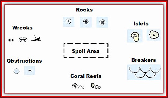
Learn to recognize rocks, wrecks, and obstructions at a glance. Below, you will find the seven most common groups of hazard chart symbols. There are many more, but you will run across these seven groups time and again.
1. Rocks
Note how the basic rock symbol looks like a plus sign. This means a rock that's beneath the water surface all the time. A symbol that looks like an asterisk means the rock will uncover (become visible) at low tide. A plus sign with dots in the corners means the rock lies just beneath the surface, even at low tide.
2. Islets (small islands)
Small islands--called "islets"--are common in the Bahamas, Caribbean, and Pacific. Islets surrounded by a solid line are visible at all tidal stages. A number indicates the maximum height at high tide (or charted datum). Islets surrounded by a wavy, squiggly line cover and uncover with the tide. At higher tides, the islet will be covered. A number indicates its height above water when uncovered at lower tidal stages.
3. Breakers
Breakers form when ocean swell meets a sea bottom that's only one to two times their height. For example, if a 2 foot swell travels over a bottom 2 to 4 feet deep, it will break.
Breakers are dangerous to any small craft because they can cause loss of rudder or propeller control.
Stay clear of any symbol like that shown in the illustration above. You may also see the abbreviation "Br" used alone without the symbol.
4. Coral Reefs
The world's most popular cruising grounds--Bahamas, Caribbean islands, and Pacific atolls--also contain some of the most dangerous waters. Study your navigational chart with care and look for the "Co" abbreviation close to any rock or islet symbol. Use Nigel Calder's techniques (see "Related Articles" link) for safe sailing navigation through coral reefs.
5. Obstructions
Easy to miss on a nautical or electronic chart display, obstructions can cause damage to propellers, shafts, and keels. Many charts use only an abbreviation "Obstn" to warn mariners. Dots around a circle mean an unknown hazard lurks beneath the surface. Tiny enclosed circles could be broken stumps, old piling remnants, or submerged poles and posts.
6. Wrecks
Fish-bones and sunken-hull illustrations make up the most common wreck symbols. Fish-bones without dots are safe to sail across. Cartographers put these on charts to warn commercial fishing trawlers not to drag nets and to caution ships not to anchor. Give fish-bones surrounded by dots or sunken-hull symbols a wide berth to avoid hull damage.
7. Spoil Area
Deadlier than the plague, identify, highlight, and stay clear of dashed outlines with descriptions like "Spoil Area", "Fish Haven", "Fish Traps", or "Dumping Ground". Ever wonder where all those old cars and trucks, building material, or garbage goes? Now you know! Spoil areas never show soundings because depths change all the time.
Danger Abbreviations You Need to Know
Familiarize yourself with the danger abbreviations used with or without the symbols described above. Study these until you know them at-a-glance:
Rk, R or Rks - Rock or Rocks
Hk or Wk - Hulk or Wreck
Obstn - Submerged Obstruction
Co - Coral
Foul - Foul Ground
These additional abbreviations may be found alongside any danger symbol, or they may stand alone. For instance "Shoal Rep" means that shallow water was reported ("Rep") at that position by a mariner, but it has not been surveyed. Stay clear of any area on your navigation chart marked by these abbreviations.
PA - Position Approximate
PD - Position Doubtful
ED - Existence Doubtful
Rep - Reported
SD - Sounding Doubtful
~~~~~~~~~~~~~~~~~~~~
Now you know how to identify any of the seven danger group symbols on any sailing chart in the world. Use these chart navigation secrets to give you the edge and keep your crew safe and sound wherever you choose to cruise.
From the eBook Quick Guide to Chart Symbols by Captain John; now available to members. Click on the link above to download your copy now!
Captain John
Related articles